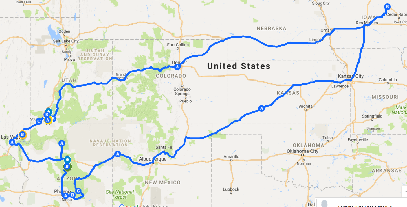
Its August... time for another Summer vacation. Usually, its a bigger trip out West, but this year we opted to stay in the Midwest and do a "short one". Of course, my desire is to continue working on my bucket list goal - Hiking the entire North Country Trail across the Upper Peninsula (UP) of Michigan (~550 miles). But with my wife joining me, I thought it would be a great for her to experience the Pictured Rocks Lakeshore loop along Lake Superior. Then, since we are up in the Upper Peninsula, I could do a couple days of solo hiking on the NCT. My wife was up for it, so off we went!

into Waterloo.
Day 1 - "On the Road Again..."
5:30 am, with Kwik Star coffee and baked goods in hand, we hit the road. By 9 am we had passed thru Madison, WI, and by 11 am were were cruising thru Green Bay, WI. Vacation "officially started" when we hit the Michigan state line entering Menominee, MI. We pulled into our hotel in Manistique, MI around 3pm Eastern time. That left us plenty of time to stretch our legs, taking the boardwalk along the Lake Michigan shoreline to the Manistique Marina, which, coincidentally had the Mackinaw Trail Winery & Brewery Manistique On the Harbor. Even with several wines to sample, we opted to check out their beers instead, and grabbed a couple outdoor chairs to enjoy the sites around the harbor.

By now, the storm clouds were building. We began the 1-1/2 mile walk back to the hotel, and walked into the lobby as the sprinkles began to fall. We also noticed there was no power in the hotel! Seemed like a good time to hop in the car to find a local establishment for dinner. With the rain and sporadic hail pounding on our car, we took off to explore Downtown Manistique.

Now, if you have ever been thru Manistique, you'll know there's not alot to explore. But a local establishment - Marley's Bar & Grill, attracted our interest. With the rain letting up, we parked, and joined the locals at Marley's. As the reviews note, this is about as close to a "sports bar" you will find in Manistique. It also appears to be the place to be in the Winter for Detroit Red Wings hockey fans to gather and support their team.
Dinner was barbeque smoked brisket sandwich with fries, and an appetizer of "Mac & Cheese Wedges". We had to try the wedges, and we were glad we did... kinda like state fair type food, wedge shaped breaded mac & cheese.. it was surprisingly good!
Finishing dinner, we headed to the Kewadin Casino just east of town to test out what our gambling luck will be this trip. This small casino is tailor made for seniors. In fact there were several motor homes parked in the lot. We joined our fellow seniors for about a 1/2 hour. No luck working for us tonite. It was time to call it a day... we thought!
Upon arrival at the hotel, the power was STILL OUT! Talking to the desk clerk, they had no idea what was going on, especially with neighboring establishments having their power working. We made the call to see if another local hotel had available rooms. Finding one that did, we grabbed our stuff, got credit for the room, and checked out. Driving 1/2 mile to the new hotel, we arrived to a lobby full of people - the power JUST went out there too! At this point, we decided to check in anyway. Using our phone flashlights, we made it to the room, and opened curtains to provide a little extra light. 20 minutes later, the power popped on, and everything back to normal..
A typical 1st day of vacation. Alot of driving, and a few activities. Tomorrow begins the hiking and exploring.
Today's trip:
~500 miles (~8 hrs) of driving
~ 3 miles of hiking
Day 2 - Pictured Rocks and more....
The first day of serious hiking was about to begin. Based on my past experiences with long hikes and bike rides, starting the day with a nourishment makes a world of difference. Wanting to get an early start and beat the throngs of people who visit the Pictured Rocks National Lakeshore daily, we checked out shortly after 6am, and headed for one of the few places in Manistique open at that time - Hardee's. Other than one senior who had already staked out his table, we were the only ones there. With the thunderstorms that passed through the day before, the morning started out with some pretty dense fog. So we decided to have our breakfast there, rather than on the road. Soon, 2-3 other senior men arrived and joined the other gentleman, and the stories and good natured ribbing between the guys in the group began. I can only imagine that this is how their days up in the UP begin, in the heat of the Summer, and the snowiest days of the Winter.
 We finished up our breakfasts and hit the road. Still a bit foggy, we began our 45 mile drive north to the Chapel Basin Parking area. Upon arrival, we found two park ranger vehicles, a couple trailers, and a handful of teens. It appeared as though they were all there for a work day on the trails. Since it was ~7:30, you could tell most of the teens were still not quite awake, as little conversation was going on. So we geared up, planning on some wetness due to the thunderstorms the night before, and the low hanging fog. Out route for the day was to take the trail past Chapel Falls to Chapel Rock, head west along the Pictured Rocks Trail to Mosquito Beach, and grab the trail which lead back to the Chapel Basin Parking area. Total distance was approximately 10 miles. The temperature was in the mid 50's, so a perfect morning to hike (eg. little to no mosquitoes and no sweating).
 The 1st 3+ miles were in tall timber areas, with a trail that was well established. A good trail to begin our day on. It was peacefully quiet thru this section, and allowed us to get re- accustomed to trail hiking.
As I experienced the 1st time I took this hike, you become used to the surroundings after 3 miles, when you begin hearing the sound of water lapping on the shore lines, and suddenly, there it is - Chapel Rock. Its such an amazing sight. This weathered pine tree perched on the top of a rock, which has been eroded for possibly centuries, leaving little for this tree to survive on. Fortunately, the Forest Service has cordoned off the area, to prevent visitors from attempting to climb across to the rock. To add to the sight, behind it was our 1st true glimpse of Lake Superior and the Pictured Rocks coastline, the next section of our hike.
 A short distance past Chapel Rock we crossed the Chapel Creek, and came upon Chapel Beach - a popular destination for kayakers taking in Pictured Rocks from Lake Superior. From here you can get a great view of Chapel Rock and the erosion of the rock from not only the wind but the pounding of the waves from Lake Superior. (Editor's Note: Can you see my lovely companion starting to tire of me telling her where to stand for a photo, and we are only 4 miles in to the hike??).

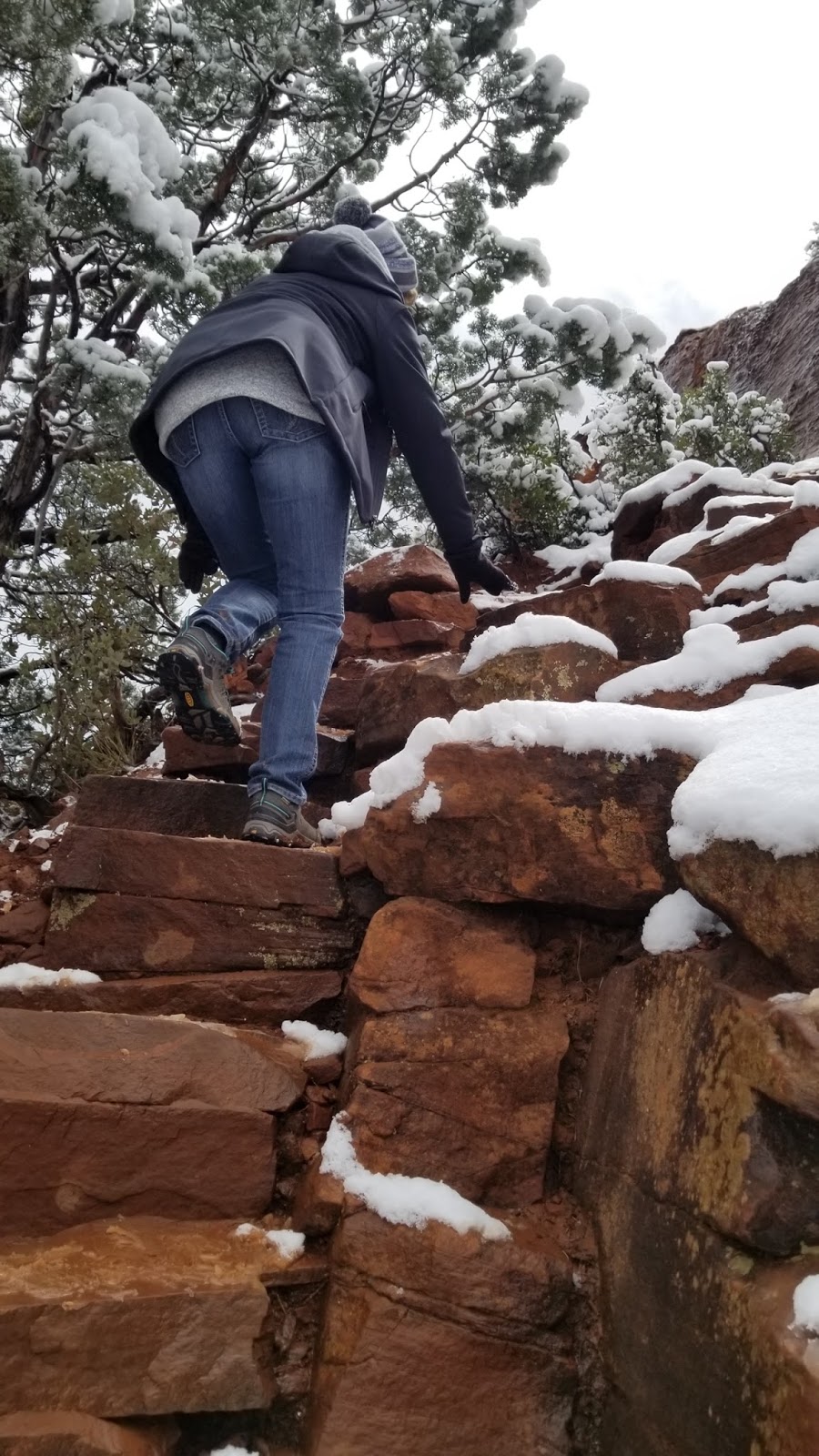
From the beach we climbed back up to the shoreline trail and began heading for the cliffs. It was on this section we finally came upon some other hikers who were just gearing up at the Chapel Beach Campground. It took us approximately a mile of hiking before we got to cliffs, and the amazing views. In many spots, you could literally walk up to the edge of the cliff and view the shoreline and cliffs around you. Simply awe inspiring!!
Once we reached Grand Portal Point, we finally ran into some hikers coming from the other direction. Fortunately, we arrived at the walkout point early enough that we got to experience the view and cliffs alone... I can only imagine what that spot is like in the middle of January, with the winds howling, and the heavy snows falling.. Its truly an amazing wilderness location that still exists today.
The trail continued in the wooded area along the top of the cliffs, for approximately 4.5 miles. All along this trail were numerous spots to step out on the cliffs for views. It made the 4.5 mile hike pass quickly. At the Mosquito Beach Campground, we came to the trail leading back to the parking area. This approximately 2 mile long hike lead us back into the wooded section of the forest, and through some areas which appeared to have had some heavy tree damage sometime in the last few year. Fortunately, the trail was clear, and we worked our tiring legs back to the car. When we arrived back at the parking lot, the entire 20+ stall lot was filled. And as we drove out, there were cars parked along the road for upwards of a 1/2 mile! (It does pay to get an early start!!!) Our total hiking experience ended up to be 9.7 miles in 4-1/4 hours.
 You've got to celebrate a great hike like this, so we headed to another UP tourist attraction - Tahquamenon Falls State Park, where the Taquamenon Falls Brewery and Pub resides! The drive was about 90 miles, but after walking for over 4 hours, no complaints from either of us to sit for the next 90 minutes. As we pulled in the entrance to pay, we found a line of about 10 cars ahead of us, and in the distance, a parking lot jammed packed. But hey, where there's a will there's a way. Sure enough, we found someone pulling out and grabbed the spot. Our 1st order of business was to let Sue experience "Upper Falls", walking the approximately half mile paved path to the Falls and the 94 steps down to the observation deck. There, we joined at least 50 others along the railing to see the almost 50 foot drop of the Tahquamenon River. OK, so a couple minutes viewing the Falls and jockeying around the tourists was enough.... time for a beer!

Day 3 - My LONG Hike....
~500 miles (~8 hrs) of driving
~ 3 miles of hiking
Day 2 - Pictured Rocks and more....
The first day of serious hiking was about to begin. Based on my past experiences with long hikes and bike rides, starting the day with a nourishment makes a world of difference. Wanting to get an early start and beat the throngs of people who visit the Pictured Rocks National Lakeshore daily, we checked out shortly after 6am, and headed for one of the few places in Manistique open at that time - Hardee's. Other than one senior who had already staked out his table, we were the only ones there. With the thunderstorms that passed through the day before, the morning started out with some pretty dense fog. So we decided to have our breakfast there, rather than on the road. Soon, 2-3 other senior men arrived and joined the other gentleman, and the stories and good natured ribbing between the guys in the group began. I can only imagine that this is how their days up in the UP begin, in the heat of the Summer, and the snowiest days of the Winter.
 We finished up our breakfasts and hit the road. Still a bit foggy, we began our 45 mile drive north to the Chapel Basin Parking area. Upon arrival, we found two park ranger vehicles, a couple trailers, and a handful of teens. It appeared as though they were all there for a work day on the trails. Since it was ~7:30, you could tell most of the teens were still not quite awake, as little conversation was going on. So we geared up, planning on some wetness due to the thunderstorms the night before, and the low hanging fog. Out route for the day was to take the trail past Chapel Falls to Chapel Rock, head west along the Pictured Rocks Trail to Mosquito Beach, and grab the trail which lead back to the Chapel Basin Parking area. Total distance was approximately 10 miles. The temperature was in the mid 50's, so a perfect morning to hike (eg. little to no mosquitoes and no sweating).
 The 1st 3+ miles were in tall timber areas, with a trail that was well established. A good trail to begin our day on. It was peacefully quiet thru this section, and allowed us to get re- accustomed to trail hiking.
As I experienced the 1st time I took this hike, you become used to the surroundings after 3 miles, when you begin hearing the sound of water lapping on the shore lines, and suddenly, there it is - Chapel Rock. Its such an amazing sight. This weathered pine tree perched on the top of a rock, which has been eroded for possibly centuries, leaving little for this tree to survive on. Fortunately, the Forest Service has cordoned off the area, to prevent visitors from attempting to climb across to the rock. To add to the sight, behind it was our 1st true glimpse of Lake Superior and the Pictured Rocks coastline, the next section of our hike.
 A short distance past Chapel Rock we crossed the Chapel Creek, and came upon Chapel Beach - a popular destination for kayakers taking in Pictured Rocks from Lake Superior. From here you can get a great view of Chapel Rock and the erosion of the rock from not only the wind but the pounding of the waves from Lake Superior. (Editor's Note: Can you see my lovely companion starting to tire of me telling her where to stand for a photo, and we are only 4 miles in to the hike??).
From the beach we climbed back up to the shoreline trail and began heading for the cliffs. It was on this section we finally came upon some other hikers who were just gearing up at the Chapel Beach Campground. It took us approximately a mile of hiking before we got to cliffs, and the amazing views. In many spots, you could literally walk up to the edge of the cliff and view the shoreline and cliffs around you. Simply awe inspiring!!
Once we reached Grand Portal Point, we finally ran into some hikers coming from the other direction. Fortunately, we arrived at the walkout point early enough that we got to experience the view and cliffs alone... I can only imagine what that spot is like in the middle of January, with the winds howling, and the heavy snows falling.. Its truly an amazing wilderness location that still exists today.


We walked back to the Brewery to find a packed house. With the sunny, humid day, I think everyone thought this was good good place to be! After about a twenty minute wait, we were seated and ordered our celebratory craft beers with a mid-afternoon snack.
By now it was 4pm... Time to make the 90 minute drive to Sault Ste. Marie, MI and our hotel - Kewadin Casino & Convention Center. Once in Sault Ste. Marie, I wanted to take Sue to
 Rotary Park on the St. Marys River first. She's not a nut like me who likes to watch the Great Lakes freighters come and go thru the Soo Locks. But if you are, Rotary Park is the perfect place. The Park is on the water's edge, and any freighter heading to/from the Soo Locks passes this location. Some freighter watching enthusiasts us this location to film the freighters (some even using drones). So we grabbed a park bench along the shoreline (no, that's not us in the photo). We just missed a "down bound" freighter (you could see it about a mile down the river. I've included a photo taken from this area (not by me) just to give you the perspective of the view from Rotary Park.

OK, NOW its time for the hotel. We checked in and had to scope out the slots in the casino. Fortunately, this casino visit was a positive one, with Sue coming out "with a few extra $$".
Day 2 had come to an end. Let's see, a 10 mile hike along Pictured Rocks Lakeshore Trail, a visit to the Tahquamenon Falls (and their Brewery), some Great Lakes freighter viewing, and a bit of gambling. Not too bad a day!
Today's trip:
~215 miles (~4.5 hrs) of driving
~ 11 miles of hiking
~ 11 miles of hiking
Day 3 - My LONG Hike....
Day 3 was the next installment of my bucket list goal to hike across the Upper Peninsula on the North Country Trail (NCT). During our trip, I planned two days of solo hiking on the NCT. The first day (Day 3 of our trip) was a 16 mile hike, beginning at Hiway 123, and ending at Trout Lake Road, near Dick, MI. Prior to this hike, I have completed 30 miles of my 550 miles, beginning near the North end of the Mackinac Bridge. My previous "way" to hike, was to park my car at the ending location of my hike, ride my bike to the starting location of my hike, and then hike back to my car. I then would drive back to the starting location, and pick up my bike. This trip I am fortunate enough to have my own personal "Uber like service" - my wife Sue. So, for this trip, Sue would drive me to the starting point, and approximately 6 hours later, meet me at the end point. For me, not having to make a 20 mile bike ride on back roads BEFORE hiking was a huge mental boost. So I was psyched to tackle these 16 miles.
 We started the morning with my obligatory McDonald's Sausage Egg McMuffin, OJ and coffee, followed by an hour drive to the drop off point. My previous hike to this starting point was thru several areas of wooded wetlands, so I assumed I would be battling mosquitoes. I dressed accordingly (long pants, long sleeved shirt, wide brimmed hat, and a mosquito net for my head in my backpack, just in case). The temperature was in the mid-50's to start, but was supposed to be in the low 70's by the time I was done. Sue dropped me off about 7:15 am and off I went. The Adrenalin was pumping, as 16 miles in an area I had never been left me a bit aprehensive. But once I got going, the enjoyment of being out in the wilderness settled in.
 This area of the NCT didn't appear to have alot of foot traffic, as several sections of the trail were almost completely covered with vegetation. Fortunately, with the "blue" marks on trees along the trail, I knew I was heading the right way. There are very few places along this section where the NCT crosses roads. So once I began the hike, either I hiked the entire 16 miles to my waiting ride, or I had to turn around, and hope that I could connect with Sue via cell phone and tell here to drive to the drop off location. Fortunately, I was able send out texts along the way, to let her know how I was doing with my pace, so she knew when to head my way. (I should note that Sue, while I was hiking, headed down to the town of St. Ignace. There, she found a coffee shop, and a park along St. Ignace Harbor, to do some reading. Once the stores started to open she did some exploring for "bargains".)
This hike was on predominantly flat terrain, so my pace was what I had anticipated - approximately 4 miles every 90 minutes. As I progressed thru the route, the wetlands began to turn into of a more wooded surroundings (and ALOT of ferns!).
 My route took me eastwardly around East Lake before turning North toward Trout Lake Road. There were times where the trail was hard to pick out, due to the surroundings. The photo to the left gives you an idea of what I was looking at... it was kinda a "Where's Waldo" experience, with me trying to locate the "blue patches" on the trail trees. The good volunteers of this section of the NCT had done a great job making sure there was always a "blue patch" within eye sight.
 I remembered the day before, when we completed our 10 mile Pictured Rocks Lakeshore hike how my legs and back were starting to tire. Today, however, when I approached the 10 mile mark, I was feeling "good to go". By the time I hit the 12 mile point, however, that 10 lb. backpack was starting to feel more like 25 lb. So the pace began to low a bit. Time to reach for some nourishment I had packed - protein bars and Slim Jim's! I continued on and suddenly came upon some interesting rock formations. This "rock cliff" continued for approximately 1/2 mile before disappearing. I learned after my trip that this might be likely a portion of the "Niagara Escarpment". Who would have thought I'd find something like this in Michigan!
Fifteen miles completed - one to go... As I get close to the end, all those little aches begin remind me how far I have come. But I see an area I remember from Google Maps that is close to the pick-up point so my pace picks up a bit. For the better part of 26 miles (10 yesterday and almost 16 today), I've avoided the infamous "root monsters". You know, the tree roots that seem to jump up and catch the toe of your shoe and trip ya?? Well, word must have gotten out that I hadn't been caught yet. Sure enough, about 1/2 mile from the end, I worked my way around a pine tree that had fallen on the trail, and as I moved my foot forward in the tall grass, I tripped on one of the branches of the tree and perfectly executed a face plant! Geeze, really? After I picked myself up, and look around to make sure noone saw that act of grace, I got back to it, knowing a cold drink, and a place to sit were not far away. Soon a forest road appeared, with the "blue patch" on the tree next to it. Hmm.. this doesn't quite seem like I remember, but hey, its marked, so I trudge on. The road leads me out onto Trout Lake Rd., my final destination.... only I am about a 1/2 mile further down the road than my pickup point. So I begin the slow walk ANOTHER 1/2 mile up the road when I see the nose of Sue's car parked back into the edge of the woods. Just as I pull out my phone to text her, I see her start to pull out and go the OTHER way! A mean trick she is playing?? No, she didn't see me initially, but finally noticed this hobbling old guy coming down the asphalt and figured it had to be me. Finally, after 16-1/2 miles, and and 6-1/4 hours, I completed this day's hike.
 You know, you never really appreciate the creature comforts we all enjoy until you experience a day like today. That car seat felt so good to finally sit down, and enjoy some nice air conditioning! It was about 1:30 pm, and I had my mind set on heading back to the hotel to get a nice COLD shower, find a place to grab some food, and celebrate another successful day of hiking. After the hour return drive to the hotel, and a shower, we headed back out again in search of The Antlers. Located on downtown's main drag in Sault Ste. Marie, this quaint restaurant serves Northern Cuisine, and had a rustic atmosphere with over 200 animal mounts everywhere in the restaurant. I immediately ordered a Yooper Ale (from Upper Hand Brewery). Man, did that taste good! We split a Turkey Pub Sub, and finished our late lunch off with a "Dessert Poutine". For those of you who have never had poutine, its generally fries covered with cheese and gravy (there are all sorts of variations of Poutine out there as well). Well, their "dessert" version was made carnival style fried batter shaped like fries, with chocolate drizzled over it. REALLY hit the spot!
After one final Yooper Ale, I slowly made it to my feet, and shuffled slowly back to the car. I announced, "I was done for the day", and we agreed to head back to the hotel, and try one more shot at the slot machines. Our luck wasn't as good as yesterday, but managed to walk out still in the black for this visit.
The "big hike" was in the books. Feeling good that I made it, but also feeling worn out, we headed back to the room. No blisters, no injuries, no ticks... about as good as I could have hoped for. One last hike for me on the NCT tomorrow. This one will only be 10 miles.... piece of cake!!
Today's trip:
Day 4 - 10 More on the NCT....


This hike was on predominantly flat terrain, so my pace was what I had anticipated - approximately 4 miles every 90 minutes. As I progressed thru the route, the wetlands began to turn into of a more wooded surroundings (and ALOT of ferns!).


Fifteen miles completed - one to go... As I get close to the end, all those little aches begin remind me how far I have come. But I see an area I remember from Google Maps that is close to the pick-up point so my pace picks up a bit. For the better part of 26 miles (10 yesterday and almost 16 today), I've avoided the infamous "root monsters". You know, the tree roots that seem to jump up and catch the toe of your shoe and trip ya?? Well, word must have gotten out that I hadn't been caught yet. Sure enough, about 1/2 mile from the end, I worked my way around a pine tree that had fallen on the trail, and as I moved my foot forward in the tall grass, I tripped on one of the branches of the tree and perfectly executed a face plant! Geeze, really? After I picked myself up, and look around to make sure noone saw that act of grace, I got back to it, knowing a cold drink, and a place to sit were not far away. Soon a forest road appeared, with the "blue patch" on the tree next to it. Hmm.. this doesn't quite seem like I remember, but hey, its marked, so I trudge on. The road leads me out onto Trout Lake Rd., my final destination.... only I am about a 1/2 mile further down the road than my pickup point. So I begin the slow walk ANOTHER 1/2 mile up the road when I see the nose of Sue's car parked back into the edge of the woods. Just as I pull out my phone to text her, I see her start to pull out and go the OTHER way! A mean trick she is playing?? No, she didn't see me initially, but finally noticed this hobbling old guy coming down the asphalt and figured it had to be me. Finally, after 16-1/2 miles, and and 6-1/4 hours, I completed this day's hike.

After one final Yooper Ale, I slowly made it to my feet, and shuffled slowly back to the car. I announced, "I was done for the day", and we agreed to head back to the hotel, and try one more shot at the slot machines. Our luck wasn't as good as yesterday, but managed to walk out still in the black for this visit.
The "big hike" was in the books. Feeling good that I made it, but also feeling worn out, we headed back to the room. No blisters, no injuries, no ticks... about as good as I could have hoped for. One last hike for me on the NCT tomorrow. This one will only be 10 miles.... piece of cake!!
~110 miles (~2 hrs) of driving
~ 16 miles of hiking
~ 16 miles of hiking
Day 4 - 10 More on the NCT....
Saturday morning... the last hiking day of this trip before beginning the long drive back to Iowa. Having just completed 16 miles yesterday, I expected to wake up with some sore muscles and a few aches. But the ol' body was feelin' good and ready to take on the North Country Trail one more time on this trip. Today's hike would only be 10 miles, since our plans had us driving back to Appleton, WI after completing the hike. Hey, after the long one yesterday, 10 miles should easy!
 While looking at the weather forecast for today's temperatures, I noticed a line of thunderstorms pressing our way. No, I did not anticipate dealing with rain on my hikes. The weather forecast had mentioned spotty showers in the late afternoons, but I anticipated being done hiking by then. Oh well, what's a little rain! Given the forecast, I opted to skip breakfast this morning, and just eat a protein bar while driving to the drop-off point (yesterday's pick-up location). It was a beautiful morning, with temps in the upper 50's, and the sun just rising. But to the West, the flashes of lightening and rumbles of thunder raised the stakes on today's hike. But then a rainbow appeared - I took it as a positive sign that my hike would be fine. As we pulled up to the trail head, and I began digging out my backpack from the back of Sue's Mazda CX5, the sprinkles began to fall. I told Sue it was time to move so I could get into the cover of the forest, and hopefully minimize the wetness. Off I went! (Since today's hike was not as long, Sue returned to Sault Ste. Marie to hang out, finding a coffee shop, and then did some quick browsing of the stores in the downtown area).
Today I opted to dress a bit lighter, as the temperatures were expected to be warmer. So I had on a short sleeve shirt (and my can of Deep Woods Off bug spray), and a lighter pair of hiking pants. The 1st portion of the trail was in tall timber, and actually did help minimize the wetness from the rain.


Today's trip:


After about a mile the trail broke out of the woods and began winding thru a more open area, but with plenty of vegetation 3-5 feet tall. Guess what, all that vegetation was wet from the rain, and within 2 minutes, my pants, shoes and socks were completely soaked. Knowing that the rain would end shortly and I would eventually dry out, I continued on. Sure enough, the rain stopped, and I finally made it into a more open area, that appeared to be a forest road likely for ATV's. This allowed me to "dry out" a bit. Even the sun attempted to break through and help speed up the drying. With this promising situation, may pace picked up and forged ahead.

The next objective was the Pine River Campground, approximately 2 miles from the end of today's hike. I had basically dried out (except the shoes and socks... those would take a couple days to dry!) when the trail led me back into another area like earlier this morning - wet vegetation. Yep, pants got soaked again. But at least I only had about 3 miles to go. The trail then worked its way back into the tall pine trees, where the ground vegetation thinned out. The adrenaline was beginning to pump , knowing I was getting close to the end. Soon, I could see a gravel road ahead, and the NCT sign indicating the Pine River Campground on Lone Pine Road.

The trail at this point began to parallel the river, which meant alot more up and down hiking. No worries, I was almost done. I was starting to feel the fatigue creeping in that always appears toward the end of a hike. But hey, 2 miles is only half what I walk every morning. So not a big concern.
The trail then crossed another gravel road. I was about 9.5 miles into today's hike, so I know I was getting close. I got out my fitness tracker app to see exactly where I was, but was unable to load the map due to poor cell reception. A NCT sign said the next major trail point was 7 miles. Hmmm.. Maybe my pickup point was just on a gravel road, not a camp area. So I forged on. "Not much further", I kept telling myself. The trail now was doing alot of "ups and downs" on some decent hills (or maybe I thought they were big hills because I was starting to wear out). I knew it couldn't be much further.... Ok, I was now at ~11 miles, and no sign of a road where I'd be picked up. Time to make a decision. Should I go to that 7 mile location, or backtrack to the last road I crossed (~1-1/4 miles). Since I had no cell reception, there was no way I could contact Sue to have her meet me at the 7 mile location. So, I opted to turn around, and head back to the gravel road. By now, I was really wearing out. That, and the uncertainty of where I was relative to my pick-up point made this last 1-1/4 miles alot of work. Finally, I turned the corner and saw a gravel road... and the nose of my wife's Mazda CX5! Yes! I made it!
Suffice to say, between my pants, shoes and socks still wet, and the extra 3 miles I walked, I was worn out. I crawled out of my back pack and wet clothes, and slipped on a t-shirt and shorts for the drive to Appleton, WI. I even had Sue help me tie my "dry" shoes... it was too much effort to do it myself.
I slipped into the passenger seat and let Sue drive, while I rehydrated and gulped down another protein bar. I could feel the life coming back to my body - partly due to the nourishment, and partly due to being in dry clothes, and knowing I was done hiking for this trip!

After about 30 miles, I was ready to assume the driver's seat, and finish the 230 miles to Appleton, WI. Arriving in Appleton, Sue had picked out the Stone Arch Brew Pub, where we could grab a good dinner, and celebrate another successful vacation getaway. Sue enjoyed a Blueberry Summer Ale with her Elk Pastrami Wrap, and I enjoyed TWO Honey Wheat Pale Ales with Mac ‘N’ Beer Cheese (Artisan four cheese beer sauce, bacon and andouille sausage). Now that's the way to wrap up the day!
We finally pulled into our hotel about 7pm. The last nite of our trip was upon us. For me, it didn't take long before I shut out the light and crashed. But that's a good thing! A full day with some good exercise, some excitement, some good food and drink, and most of all, another great adventure with my wife!
Today's trip:
~310 miles (~6 hrs) of driving
~ 13 miles of hiking
Day 5 - Home, Sweet Home..
The drive from Appleton, WI to Waterloo was only 300 miles (4.5 hours), so with our early start, we were back by 11:30 am. That gave Sue time to run to the boarding kennel and pick up our dog Chester. Nothing better than getting home after a great vacation, and to have your "little buddy" excited to see you (actually he was probably more excited to be out of the boarding kennel!).
Although the trip we took was not everyone's idea of fun, it was "our kind of trip". We got to explore new places, get in some hiking, check out the local establishments, and enjoy some time together. For this trip, it was almost 1,500 miles of driving. Total miles hiked - 43.
So where to next? New England. We've always wanted to drive the beautiful back roads and coastline of New England during the Fall, so we decided 2018 is the year to do it. Fortunately, the Iowa Hawkeyes Football schedule is perfect for us sneaking in the trip in early October and not miss any home games (season ticket holder since 1980). Planning is underway..... so stay tuned!!